| 1. | ||
| 2. | ||
| 3. | ||
| 4. | ||
| 5. | ||
Shape Factor Coefficient Implementation on Calculation of Agricultural Loss in Uzbekistan
Sherzod K. Rakhmonov
Department of Mine Surveying and Geodesy, Tashkent State Technical University; Tashkent City, Uzbekistan
Email address

Citation
Sherzod K. Rakhmonov. Shape Factor Coefficient Implementation on Calculation of Agricultural Loss in Uzbekistan. American Journal of Civil and Environmental Engineering. Vol. 1, No. 2, 2016, pp. 19-23.
Abstract
Article discussed about one of today’s actual issues to optimize selection and land allocation for non-agricultural enterprises. The scientific work reviewed by a need individual approach for each of polygon, line and point feature. Since polygon, line and point features requires special treatment and individual approaches. Case study was carried out in Buka and Chinaz districts. It was recommended to implement a new coefficient for calculation of damage to agriculture on neighboring land users.
Keywords
Land Allotment, Non-agricultural Use, Land Use, Irrigated Land, Coefficient, Agricultural Product, Line Feature, Polygon Feature,
1. Introduction
Land allotment requires to take into consideration many factors such as loss of agricultural product, irrigated land, geographical and physical hindrance, etc. Since Uzbekistan has limited irrigated land and ever-growing population, it is recommended to use every hectare cautiously to keep providing agricultural products for local people (to be independent from importing products).
It takes thousands of years for Soil to be formed and developed in. Therefore, it is actually difficult to assess real cost of soil. Cost and environmental protection has to be primary consideration when land allotment is made for non-agricultural purpose [13]. However, agricultural loss can be approximated by modelling land allotment [14]. Research paper tries to approach to modelling and implement shape factor to cover farmers expenses and agricultural loss for the next few years. Shape factor refines calculation of agricultural loss. Land allotment shape is generalized into point, linear and polygonal objects.
2. Study Area and Methodology
Uzbekistan is one of the former Soviet country, got independence 26 years ago. The Republic of Uzbekistan with a population of more than 31 million people and area of 447,400 square km is located in Central Asia. The urban population is 32% and the rural population 68%. Uzbekistan is divided into 12 administrative provinces and 1 autonomous republic and 1 capital city (Figure 1).
It has its own way of development. It does not only choose some other countries experience blindly, but researchers has studied most developed countries and retrieved possible solutions for local case. Since Uzbekistan has kept property right to land for itself, so state is a major reformer of land attitudes in the country. Uzbekistan launches law that regulates land relationship and its formation. During the transitional period, the country decided to work out its own way of becoming a renewed, developing sovereign democratic republic oriented to a modern market economy. The Government has adopted the new legal and economic policy under which privatization, deregulation and decentralization play a major role. One of the most urgent key question problems of transition was to solve a land reform. As a result of land reform, the earlier systems have been replaced. However, land belongs to the State and people may enjoy only rights to use land. Apart from land, buildings and structures have been privatised. Almost all residential and small houses are private. Industrial buildings were privatised mostly by the workers. Commercial and industrial buildings were sold in auctions and the workers in industrial buildings had a priority to buy the building.
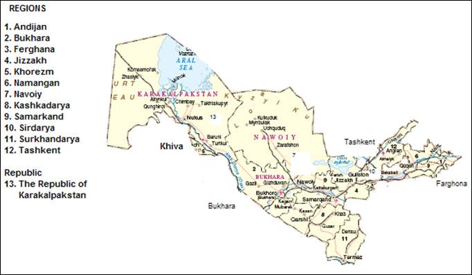
Fig. 1. Territorial division of Republic of Uzbekistan.
In Uzbekistan concept buildings and structures constitute a real property. Therefore, private Property is dominating now and only having use rights to the land on which it is located. Anyone knows that private property operates as the main force that raises the productivity, creates a good environment for nations to make wealth, and therefore has a leading role in economic development. Today, many individuals and firms have freedom and incentives to conduct their own economic activities and businesses in accordance with market principals. New entrepreneurs who take responsibility for managing a new business generally face financial difficulties. New businesses often require additional financing and land plot. However, the main problem in the transitional period is the lack of financial resources and land plot that located in a good geographic location. In order to respond to the problem, much attention should be paid to the development of a land use planning and to its main components.
Agricultural land uses in rural areas take three main forms of tenure:
1. Dekhkan (peasant) Farms – usually a rural house with a small land parcel (up to 1 hectare) attached to it. The land is held as a life-long inheritable possession [3].
2. Lease Farms – land plot that leased by the Khakim (head of the municipality) to a lessee for periods of 10-50 years [4].
3. House – Lifelong Inheritable Possessions and Permanent Use Rights [5].
People of rural areas also use a wide range of strategies to gain access to land and real property. And they are:
Ÿ Purchase, often using capital accumulated while working as migrants in urban areas or abroad. People can buy for capital gained from their annual crops and yields
Ÿ Leasing, or gaining access to land by paying rent to the Government.
Ÿ Inheritance or gaining access to land as an heir.
Ÿ Informal buying of land parcel for building purposes. Currently due to population growth and market economy policy people are buying and occupying land and later documenting it through Cadastre Service. Especially it is observed in rural areas.
In addition to such individual strategies, access to land can be provided systematically through land reform interventions by national governments, often as a result of policies to correct historic injustices and to distribute land more equitably.
Fortunately, the positive sides of the land tenure, in Uzbekistan, include a wide spread access to land, the absence of squatting and numerous functioning land administration procedures that contain data with amazing coverage. But contrary to western countries real property wealth has not been employed as a catalyst for development. It has much to do with the main constraints in the whole formal property system.
Uzbekistan plays a key role in the land use planning and the rest of the ministries, municipalities, authorities and public plays a complementary or executive role. The list of actors in the process is fulfilled with the Cabinet of Ministers, regional municipalities, autonomous republic, and design developers and of course with public. Therefore, entrepreneur who wants land plot can not get agreement with farmer for construction without permission from khakim who speaks from name of state.
Since state owns land, farmer has right to use it only. Government has launched law that regulates land allotment. According to the law a formulae is used to calculate loss of agriculture when allotting land from agriculture to non-agricultural purpose to cover farmer’s loss by giving away productive soil/land. Farmer can use this to cover his loss by giving away his land plot. He may be given another non-irrigated land in order to fulfill his lost land [11]. In that case he is required to increase fertility rate of that land he lost from his land. The formulae for calculation of agricultural loss during land allotment for permanent use for non-agricultural use is determined by the following formula [2]:
Ps = {{[(Cor. X Sor.) + (Cbog. Sbog x.) + (X Cor Sz.or. x 0.1) + (Cbog. Sz.b. x x 0.1) + (Cs.p. Ss.p. x)] x} Key x Km + PCh}*Csh, where:
Ps - loss of agricultural production in the seizure of agricultural land for permanent use, thousand soum (Uzbekistan money);.
Cor. - The cost of irrigation and development of new land equivalent in lieu of 1 ha of irrigated agricultural land (except irrigated deposits), adopted pursuant to paragraph 31 [2]; thousand soum.
Cbog. - The cost of irrigation and development of new land equivalent in lieu of 1 hectare of non-irrigated arable land and rainfed perennial plants, adopted pursuant to paragraph 32 [2]; thousand soum.
Cs.p. - The cost of irrigation and development of new land equivalent in lieu of 1 ha of hayfields and pastures, adopted pursuant to paragraph 34 [2], thousand soum;
Sor. - Area of irrigated farmland withdrawn (except irrigated deposits), m;
Sbog. - An area seized rainfed arable land and non-irrigated perennial crops, ha;
S h op. - Area of irrigated deposits withdrawn, ha;
H S b. - An area seized rainfed reservoirs, ha;
Ss.p. - An area seized hayfields and pastures, ha;
Km - coefficient taking into account the location of the land plots shall be adopted in accordance with paragraph 36 [2];
Ki - indexation coefficient amount of agricultural production losses, taken in accordance with paragraph 48 [2];
PCh - the amount of net income received on the land plots in the last four years, it is determined in accordance with paragraph 35 [2], thousand soum
Csh – coefficient to the shape of land allotted (polygon, area, point)
Following formulae is used to calculate agricultural loss which covers farmer’s loss by allotting land for non-agricultural land using.
3. Background
Nowadays, Uzbekistan has 4.2 mln ha irrigated and 16.2 mln non-irrigated land. While population has increased by a little over 1.5 times from 20.5 mln to 31 mln since 1991. So peoples’ consuming needs have been increased mathematically for agricultural products by approximately 1.5 times. Therefore to keep independence on importing agricultural products from other countries, Uzbekistan has chosen to keep agricultural land as less degraded as possible for future generation.
Uzbekistan has system so called land bonitet (quality of land). It measures productivity of land from 0 to 100 ball. 0 means worst productive land to 100 the most productive [7]. Law [1] allows to give away land for non-agricultural purpose up to 40 ball and only through permission Cabinet of Ministries. Current law regulates to calculate loss of agriculture1 while being transition to non-agricultural land2. When agricultural land transferred to non-agriculture, land loses its productivity/fertility and it usually does not restore to its previous condition.
The Planning process in Uzbekistan according to the laws starts from order of Cabinet of Ministers and regional municipalities to develop new plans depending on their competence. Then relevant authorities order the licensed design organization to make an urban planning plan. Design organization then investigates, collects and compiles preliminary data for the development of the urban planning document [6].
4. Case Study and Discussion
Law does not take into consideration shape of land allotment to calculate loss of agriculture for all cases even it is polygon, linear or dotted (point) object. Therefore, it is advised to add coefficient for polygon objects 1, for linear 1.5 and dotted 2.0. Moreover, all non-agricultural land has to be classified in order to be implemented these coefficients. Here are some examples for polygonal, linear and point objects:
Ÿ polygonal object - building, plant, factory, etc [6];
Ÿ linear object – road, highway, railway, etc [6];
Ÿ point objects – power supply network, communication supply network, road sign, etc (author).
Table 1. Grouping of affection of land allotment on neighboring (surrounding) land users [12].
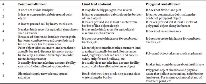
Table 1 discusses affection of land allotment for polygonal, linear and point objects on neighboring (surrounding) land users. It covers how allotted land may reflect or damage agricultural land.

Fig. 1. Polygon, linear and dotted objects and 1 their damages to neighboring land users.
Since polygon is an areal object therefore, it brings less problem for neighboring land users like couple of meters surrounding borders only. For instance, house was built in 0.04 hectares in Kibray district, Tashkent province. It did not damage land more than it is placed. And in most cases it does not bring more hindrance to surrounding land users [8].
Linear creates more problem such as pressing soil a couple of meters, sometimes even more, by a heavy truck, an excavator and others. Moreover, construction such as road or railways leaves tons of road metal or some other trashes because it is inevitable while construction. So when allotting land for non-agriculture purpose, it is required to calculate not only road/railways is occupied but several meters from the road/railway border have to be removed from agricultural land. Farmer does not have to pay extra tax for land that is not used on agricultural purpose or damaged. For instance, new road built in Buka district connecting 2 villages about 26 km [9]. It left apart from 8 meters approximately 2 meters from each side mostly with construction trashes and pressed soil by heavy trucks and bulldozers.
Point objects leaves even more problems. For instance, construction of electricity network requires to build post/pole in the middle of farming land. Since tractor cannot cultivate land just on the border of electricity post/pole, it is needed to extract 5 meters from border of post/pole from farming land and calculate loss of agriculture land accordingly. Therefore, loss of agriculture is obvious in that area. High voltage electrical network was constructed between Buka and Chinaz district [10]. It is 87 km long. However, each post/pole has covered up to 0.005 ha while creating hindrance upto 0.01 ha surround. So therefore, it is recommended to cover multiply loss of agriculture to coefficient 2.0.
Table 2. Area of occupied land plot and its creation hindrance to neighboring/surrounding land users, in hectare.
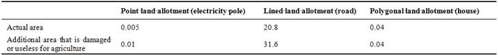
Table 2 represents about area of occupied land plot and its creation hindrance to neighboring/surrounding land users. Results shows polygon object occupies what it actually locates. While linear object requires more land than it actually located. It is about 1.5 times more. Point object occupies less land, however, it creates more hindrance for agricultural machines (tractor) to cultivate or harvest crop.
5. Conclusion
Land allotment is complicated process which combines many factors altogether. Current regulation covers most factors. However, it would be good to add another coefficient to enhance it. Real case studies show that when land is allotted for non-agricultural use it is recommended to add new coefficient such as 1 for polygon, 1.5 for linear and 2 for point objects. This will lead to increase money flow to farmer’s special fund which is used to increase fertility of soils of irrigated land or to transfer from salinized land into cultivated land.
References


